
Cosmography
In the late fifteenth century, Portugal stood at the center of a scientific revolution that merged Christian, Jewish, and Islamic knowledge of the heavens and the earth. Known in the royal chronicles as cosmografia, this discipline united practical astronomy, latitude calculation by solar declination, and secret cartography. Before Pêro da Covilhã and Afonso de Paiva departed Santarém on May 7, 1487, they were briefed and equipped with a classified world map drafted by King Dom João II’s royal cosmographers of the Junta dos Matemáticos—Bishop Diogo Ortiz de Vilhegas (“Calçadilha”), Doctor Rodrigo, and the Jewish astronomer Mestre Moisés—whose work relied directly on instruments and astronomical tables inherited from al-Andalus and the Maghreb.

Title page from the 1558 Italian edition of Sebastian Münster’s Cosmographia Universalis (first published in Basel, 1544), depicting the marriage of royal power, geography, and celestial measurement.
Cosmographers
Behind every successful voyage and clandestine mission commissioned by King Dom João II stood the Junta dos Matemáticos—a specialized royal scientific committee established in Lisbon around 1484 to overhaul Portuguese navigation.
As Portuguese caravels pushed south across the Equator, navigators encountered a profound crisis: the North Star (Polaris), which had guided mariners for centuries, sank below the northern horizon and disappeared from view. Without it, dead reckoning alone spelled disaster on the open ocean.
King João II charged the Junta—comprising Bishop Diogo Ortiz de Vilhegas (“Calçadilha”), Doctor Rodrigo, and the Jewish astronomer Mestre Moisés, alongside the exiled Spanish astronomer Abraham Zacuto—with developing practical methods to calculate latitude using the midday sun.
The Junta successfully adapted medieval Arabic and Hebrew astronomical tables into simplified solar declination manuals and standardized navigational charts (cartas de marear). When Pêro da Covilhã and Afonso de Paiva stood before King João II in Santarém on May 7, 1487, it was this Junta that provided them with their state-secret navigational chart and instructions—bridging the gap between scholarly Islamic cosmography and Portuguese oceanic empire.

Painéis de São Vicente de Fora (The Panels of St. Vincent), attributed to royal painter Nuno Gonçalves, c. 1470–1480 (Museu Nacional de Arte Antiga, Lisbon).
Painted during Pêro da Covilhã’s youth, this monumental six-panel polyptych offers a vivid window into the fifteenth-century Portuguese court under King Dom Afonso V and the young Prince Dom João II. Alongside royalty, knights, monks, mariners, and fishermen stand royal chroniclers, astronomers, and Jewish court scholars—including a figure in the right-hand Panel of the Relic holding an open Hebrew book—illustrating the exact intellectual milieu from which the Junta dos Matemáticos emerged.
Astrolabes
Chief among the scientific instruments of the medieval Mediterranean and Islamic world was the astrolabe (Arabic asṭurlāb, from the Greek astrolabos, “star-taker”). Functioning simultaneously as an observational altitude-finder and an analog celestial computer, a brass astrolabe enabled a skilled user to measure the altitude of the sun or fixed stars above the horizon, tell the hour of day or night, determine terrestrial latitude, cast astronomical tables, and—in the Islamic world—calculate the times of daily prayer (ṣalāt) and the true compass bearing toward Mecca (qibla).
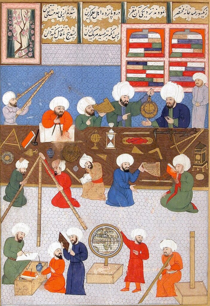
Astronomers working with planispheric astrolabes, quadrants, an armillary sphere, and a terrestrial globe at Taqī al-Dīn’s observatory in Constantinople (c. 1577). Miniature from the Shāhnāma-yi Shāhinshāhī of ‘Alā’ ad-Dīn Manṣūr Shīrāzī (1581), Istanbul University Library (MS F. 1404, fol. 57a).
The Hispano-Maghrebi Astrolabe and Saphea
Long before the Portuguese simplified the complex astronomer’s astrolabe into the heavy, open-ring astrolábio náutico (mariner’s astrolabe) to measure solar altitude on a rolling ship’s deck, fifteenth-century scholars, overland travelers, and royal cosmographers relied on finely engraved brass planispheric astrolabes inherited from Islamic Spain and the Maghreb.
Yet an overland explorer like Pêro da Covilhã—whose itinerary carried him from the Mediterranean across the Tropic of Cancer to Aden, Calicut, and south of the Equator to Sofala—faced a fundamental geometric limitation with the traditional astrolabe. On the front of a standard astrolabe, the mater houses interchangeable brass disks (climate plates or tympans), each engraved with altitude circles (almucantars) calculated for a single, specific latitude. Once a traveler went beyond the latitudes of his plates, the instrument could no longer map the local sky.
The classic medieval planispheric astrolabe pictured here—and featured on the cover of Terra Barbaria—is a masterpiece of silver-inlaid brass crafted and signed in 1291 CE by the Rasulid prince and astronomer ‘Umar ibn Yūsuf of Yemen (now preserved in the Metropolitan Museum of Art). While its pierced rete and interchangeable climate plates represent the pinnacle of traditional Islamic astrolabe design, a traveler crossing into uncharted latitudes required an even rarer Andalusian innovation.
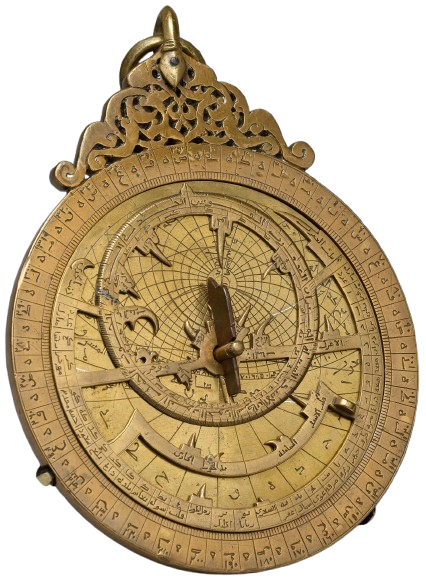
Planispheric astrolabe crafted and signed by the Rasulid prince ‘Umar ibn Yūsuf (later Sultan al-Ashraf ‘Umar II of Yemen), dated 690 AH / 1291 CE. Brass inlaid with silver. The Metropolitan Museum of Art, New York (91.1.535a–h).
The Universal Solution of az-Zarqālī
To overcome this limitation, Andalusian and Maghrebi instrument makers combined the classic planispheric astrolabe on the front with a universal projection on the back known in Latin Europe as the Saphea Azarchelis (aṣ-Ṣafīḥa az-Zarqāliyya). Devised in eleventh-century Toledo and Córdoba by the renowned astronomer Abū Isḥāq Ibrāhīm az-Zarqālī (known to the Christians of Castile and Portugal as Azarquiel), the Saphea projected the celestial sphere stereographically from the equinoctial points rather than the pole—creating a single, universal grid that functioned at any latitude on Earth.
It is just such an instrument that Pêro obtained in the Sultanate of Tlemcen in the first novel, Terra Barbaria, of the Covilhã’s Secret Journal series.
Anatomy of a Fifteenth-Century Maghrebi Combination Instrument
The fifteenth-century Maghrebi brass instrument illustrated here (19.4 cm in diameter) exemplifies the tools circulating between Andalusia, Fez, Tlemcen, and Cairo during Covilhã’s lifetime:
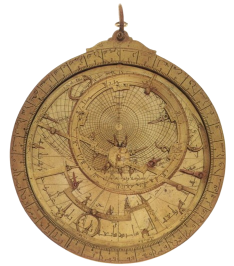
Obverse of a 15th-century Maghrebi brass astrolabe (Ø 19.4 cm), showing the pierced star-map (rete) with thirty star pointers, the zodiacal ecliptic ring, and the underlying latitude plate. Formerly Time Museum Collection (Inv. No. 1935; after A. J. Turner, 1985).
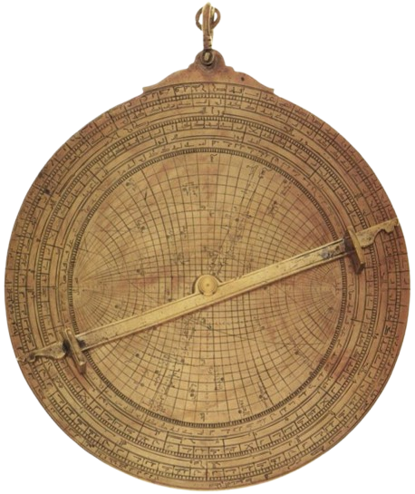
Reverse of the same instrument, engraved at its center with the universal projection of az-Zarqālī (Saphea Azarchelis) marking thirty-six stars, encircled by an eccentric zodiacal calendar bearing Western month names and outer altitude and shadow scales (after A. J. Turner, 1985).
Other Instruments
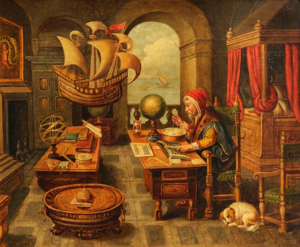
Lapis Polaris, Magnes (The Lodestone & Magnetic Compass), engraved by Philips Galle after Jan van der Straet (Stradanus) for the Nova Reperta series (Antwerp, c. 1590). A cosmographer works at his table with a magnetic compass, lodestone, dividers, and a brass astrolabe beneath a suspended ship’s model, while ocean-going caravels and carracks sail across the horizon.
While the complex planispheric astrolabe and the universal Saphea remained the domain of astronomers and royal cosmographers, practical travelers, pilots, and sea captains relied on a rugged trio of instruments to survive the open ocean: